Viareggio, Italy (April 23, 2025) – C-MAP®, a leader in digital marine cartography and cloud-based mapping, today announced its first major update to European charts for 2025.
This new update improves cartography across our DISCOVER®, REVEAL® and X Generation charts, exclusive to Lowrance®, Simrad® and B&G® chartplotters. In this update, C-MAP has improved both High Resolution Bathymetry and Shaded Relief across Italy, Scotland, Ireland, Netherlands, Spain and France, to bring even more detail to our users. This is also the first time that C-MAP is introducing an ENC only mode, so users can see the official Hydrographic charts without any proprietary C-MAP data added.
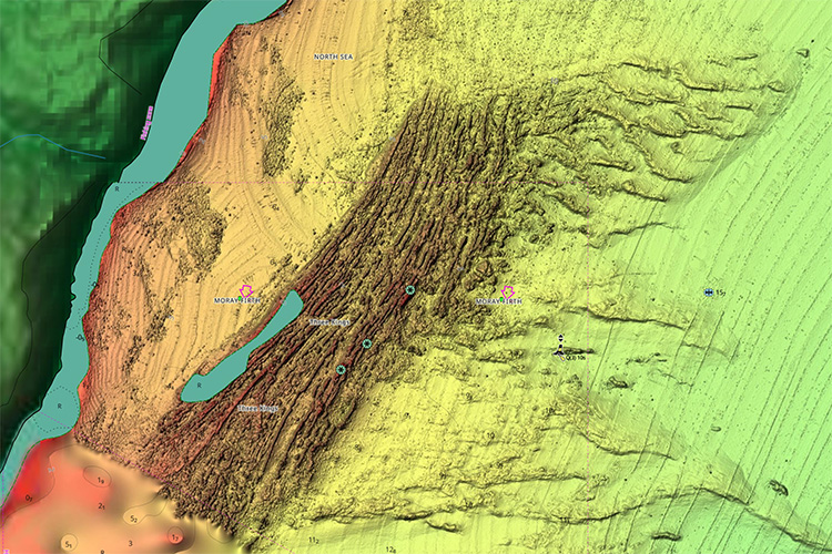
Moray Firth, Scotland
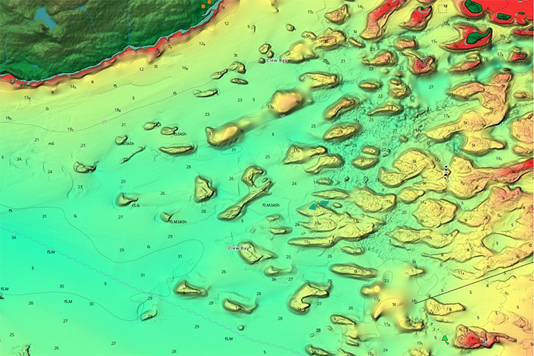
Clew Bay, Ireland
"We're excited to announce a new update for our C-MAP users in Europe, helping them prepare for the upcoming season," said Jakob Svensson, C-MAP Product Manager. "Our dedicated product team is focused on sourcing the most up to date data and consistently enhancing our charts."
The new data improves the DISCOVER®, REVEAL® and X Generation charts from C-MAP and is available to new users or any existing users who purchased a chart in the past year and subscribed to C-MAP. Users can view the latest charts for their location online at c-map.com/chartexplorer.
Updates for European charts include:
- Standard updates include the latest NOAA ENC navigation data.
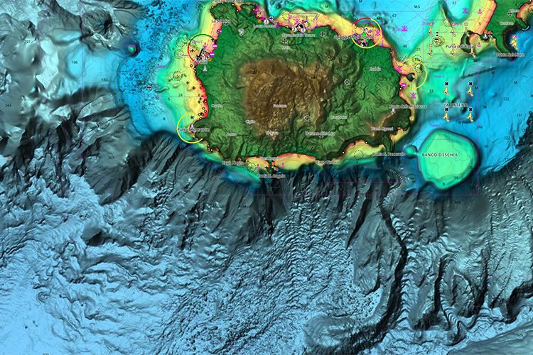
- Improved Shaded Relief & High-Resolution Bathymetry across Italy, including Gulf of Naples and Ligurian Sea.
- Improved Shaded Relief & High-Resolution Bathymetry across Scotland, specifically in the Moray Firth.
- Improved Shaded Relief & High-Resolution Bathymetry across Ireland, specifically at Clew Bay.
- Improved Shaded Relief & High-Resolution Bathymetry across Netherlands, including Vllestroom, Terschellingerwad & Het Rif.
- Improved Shaded Relief & High-Resolution Bathymetry across France, including Band D’Arguin & Le Bassin d’arcachon.
Shaded Relief and Satellite imagery are exclusive to C-MAP Reveal and Reveal X and are available on a range of chartplotters from the Lowrance®, Simrad® & B&G® brands.
About C-MAP®
C-MAP is part of Navico Group, a division of Brunswick Corporation’s (NYSE: BC), and is a leader in digital marine cartography and cloud-based mapping, offering one of the world’s largest marine navigation digital chart databases. C-MAP’s portfolio includes the DISCOVER™, REVEAL™, and 4D™ chart ranges, which integrate with fishfinders and chartplotters from the leading marine electronics brands, and via the C-MAP App available on the App Store and Google Play.
About Navico Group
A division of Brunswick Corporation (NYSE: BC), Navico Group is the world’s leading supplier of integrated systems and products to industries ranging from marine to recreational vehicle and beyond. The Navico Group portfolio is comprised of industry-leading brands in power management, digital control & monitoring, networked devices, and marine electronics. Some of the many brands that make up Navico Group include: Ancor, Attwood, B&G, BEP, Blue Sea Systems, C-Map, CZone, Lenco, Lowrance, Marinco, Mastervolt, MotorGuide, Progressive Industries, ProMariner, RELiON, Simrad, and Whale.


