
![]()
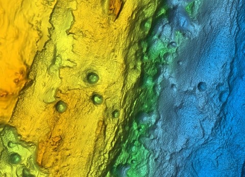
Ultra-High Resolution Bathymetric Imagery – Superior identification of the sea floor. View the sea floor in a whole new light. Clearly identify sea floor structure, along with reefs and ledges to find the best fishing and diving spots. C-MAP Reveal will take your charts to the next level. (Coverage: USA, UK, Australia & New Zealand)
** Not compatible with Lowrance HOOK², HOOK Reveal or Simrad Cruise.
MAX-N+ STANDARD CHARTS
Local
The most complete mapping experience for avid salt water anglers with the best fish-finding features packed in. (Coverage: Global)
Wide
Advanced chart detail and feature-rich content with larger coverage areas for far-ranging boaters and fishermen. (Coverage: Global)
Continental
The largest geographical coverage with features such as harbour plans and easy routing, they make navigation a breeze. (Coverage: Global)
FULL FEATURED VECTOR CHARTS

Full Featured Vector charts make navigation easy by giving you accurate, up-to-date vector chart detail derived from official hydrographic office information.
HI RES BATHYMETRY LAYER

High-Res Bathymetry (HRB) Layer helps you identify shallow areas, drop offs, ledges, holes or humps.
CUSTOM DEPTH SHADING

Custom Depth Shading provides many options to set a safety depth, maintain a paper like view or your own custom color for depths.
EASY ROUTING

Easy Routing helps you automatically plot the shortest, safest route based on detailed chart data and your vessel information.
C-MAP GENESIS LAYER

C-MAP Genesis Layer adds 1 foot depth contours on top of traditional C-MAP Charts, compiled from Genesis social mapping.
SHADED RELIEF**

Shaded Relief brings the world around your vessel to life with 3D rendered land and underwater elevation. **Not available in Continental & Insight Pro
SATELLITE OVERLAY**

Satellite Imagery gives information about the surroundings when you find yourself in unfamiliar places. **Not available in Continental & Insight Pro
RASTER CHARTS

Raster Charts provide a traditional chart look and feel coupled with easy access to all objects on the charts.
AERIAL PHOTOS**

Aerial Photos are a collection of thousands of photos of marinas, harbors, inlets and other notable navigational features included to offer an additional level of detail. **Not available in Continental & Insight Pro
TIDES & CURRENTS

Tides & currents show projections of water level and direction of tides to help plan your day out angling or sailing.
HARBOR AND APPROACH DETAILS

Unprecedented level of detail. Approach any harbour and inlet with confidence. The perfect conclusion to a long voyage, sailing adventure or exciting day of fishing.
DETAILED MARINA PORT PLANS

Docking in an unfamiliar port is no problem, when you have precise layouts of thousands of marinas, including slip spaces, restricted areas, and other valuable navigation information.
COMPATIBILITY
Compatible with B&G, Simrad & Lowrance chartplotters.COVERAGE
C-MAP data and features you want with coverage options ideal for each budget and boating need. Whether you’re a long-distance cruiser, avid angler or sailing enthusiast - C-MAP has you covered. Find out more about C-MAP Chart Features.
MAX-N+ is available in Local, Wide and Continental formats.


