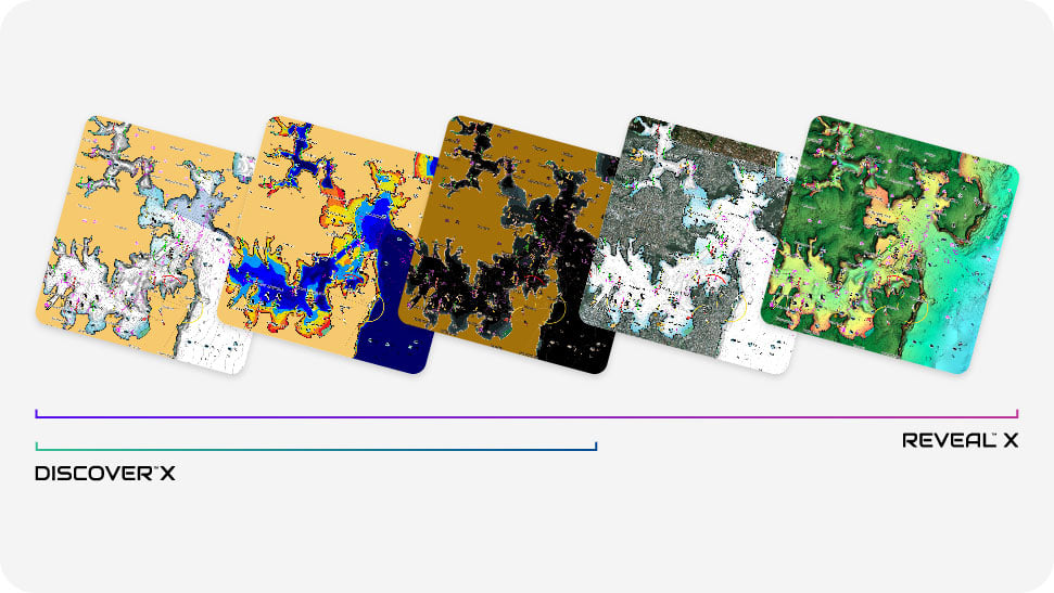
THE X GENERATION OF CHARTS
Compatible with Simrad® and B&G® running NEON™ OS.
Compatible with Simrad® and B&G® running NEON™ OS.

Compatible with Simrad® NSX™
and B&G® Zeus® S
Always have the latest chart data at your fingertips with the C-MAP X range. With dynamic presentation ensuring a clear, uncluttered view at all zoom levels, best-in-class Day & Night modes, the most detailed High-Res Bathymetry plus an intuitive Map Inspector Tool. Both DISCOVER® X and REVEAL® X deliver smooth integration with the C-MAP®-powered Simrad® and B&G® Companion Apps.
Rich features include Custom Depth Shading, Tides & Currents and subscription-free Autorouting, plus 12 months free online updates. Upgrade to REVEAL™ X to enhance your time on the water, unlocking additional layers, including Shaded Relief and Satellite Overlay.
Next-Generation Charts
Refreshed chart presentation, with full-featured vector data and rich features
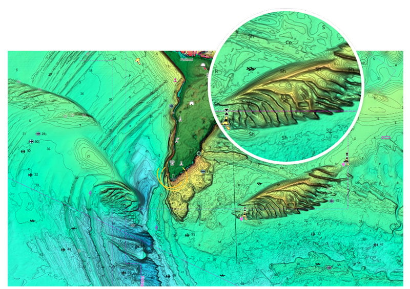
High-Res Bathymetry
The best C-MAP® bathy data, with an intuitive Map Inspector tool
Custom Depth Shading
Set a safety depth and create your own custom colouring to level-up your fishing
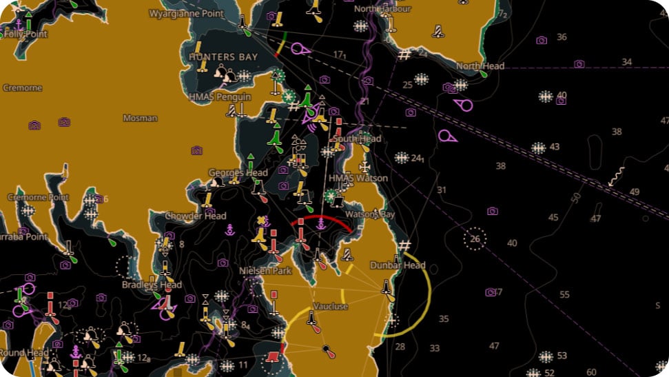
Day & Night Mode
Best-in-Class Day & Night Modes ensure best visibility in all light and weather conditions
Satellite Overlay
Maximise your situational awareness with a bird’s-eye view * only with REVEAL™ X
Shaded Relief
Bring the world around you to life like never before * only with REVEAL™ X
Next-Generation Charts
Refreshed chart presentation, with full-featured vector data and rich features
High-Res Bathymetry
The best C-MAP® bathy data, with an intuitive Map Inspector tool
Custom Depth Shading
Set a safety depth and create your own custom colouring to level-up your fishing
Day & Night Mode
Best-in-Class Day & Night Modes ensure best visibility in all light and weather conditions
Satellite Overlay
Maximise your situational awareness with a bird’s-eye view * only with REVEAL™ X
Shaded Relief
Bring the world around you to life like never before * only with REVEAL™ X
Get premium access to the C-MAP® app for 12 months with any purchase of C-MAP DISCOVER™ X or REVEAL™ X charts. Gain access to exclusive features like your GPS Position, 5-day Weather Along the Route, Anchoring Alert and more. Experience new layers including Shaded Relief and Satellite Imagery.

![]()
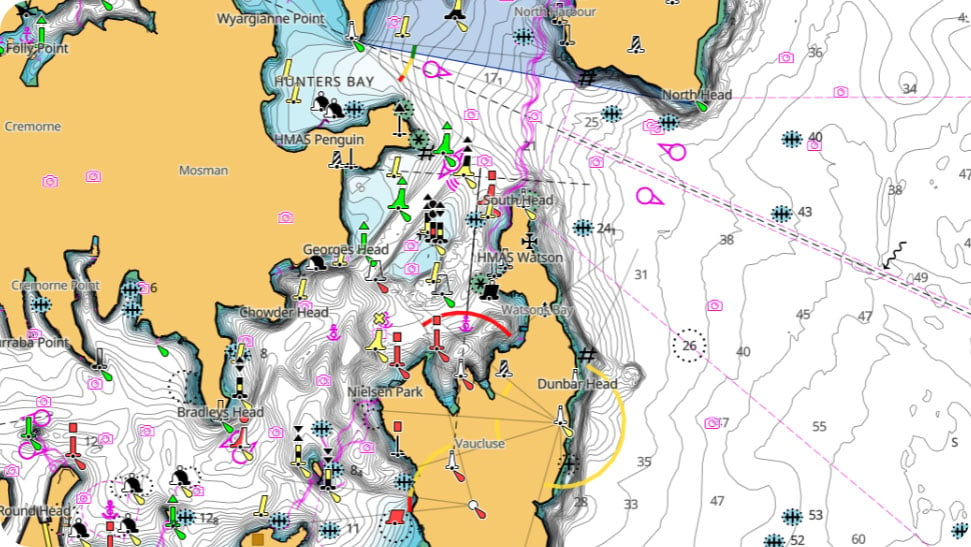
Discover a more intuitive navigation experience. DISCOVER™ X combines the latest and best of C-MAP® data with all the key features you need for a safe, stress-free journey – whatever the time of day and whatever the weather.
Navigation is clearer and more intuitive than ever before. With the latest tools, best-in-class Day and Night modes and improved Autorouting, you can always make the most of your time on the water.
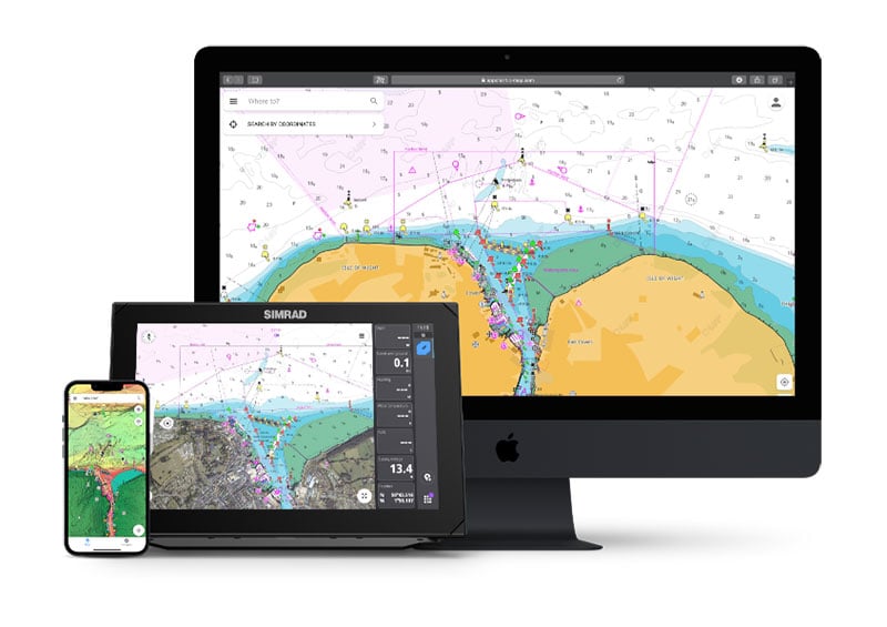
Integration with the C-MAP®, Simrad® and B&G® Apps brings the beauty of X-Gen charts to all your devices. Users already running X-Gen charts on their chartplotter will gain the ability to explore charts on tablet and mobile. Plan trips, review Tracks and plot Waypoints using the App, and sync directly to your chartplotter, with no additional subscription required.
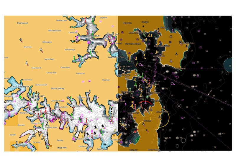
Dedicated Day and Night Modes, created to ensure maximum visibility and ease of use in all light and weather conditions. Always see the detail you need. Stay safe and navigate with ease.
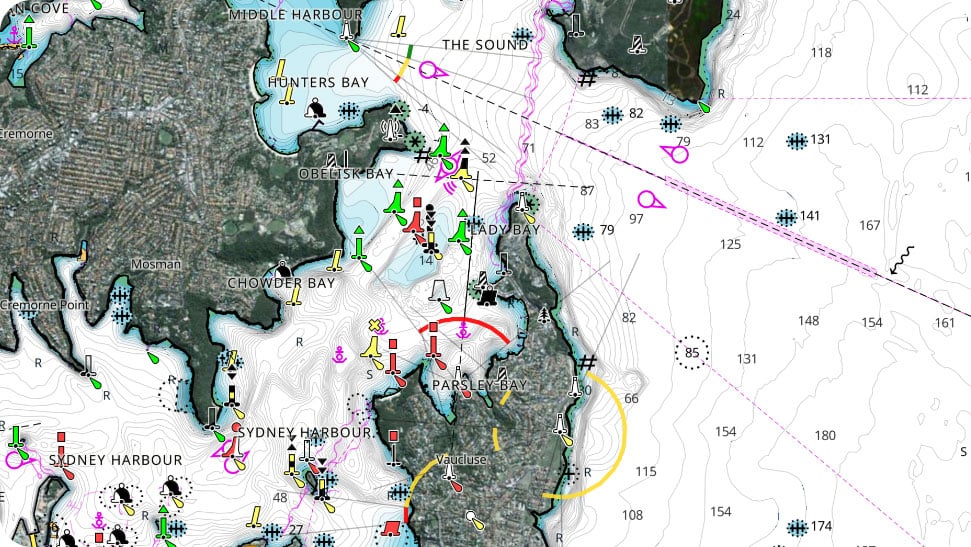
Makes navigation easy by giving you accurate, up-to-date vector chart detail derived from official sources, including hydrographic offices.
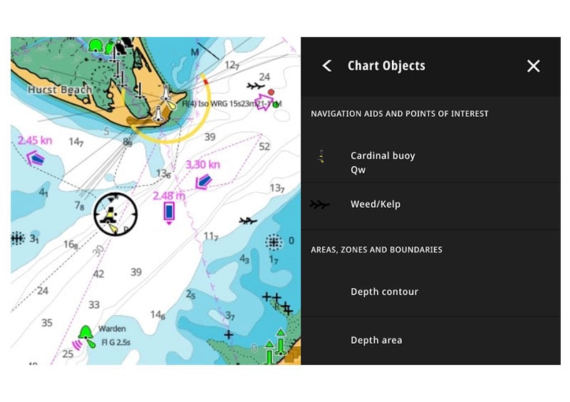
Quickly see information on locations, POIs, tides, channels and more, with a simple touch of the screen.
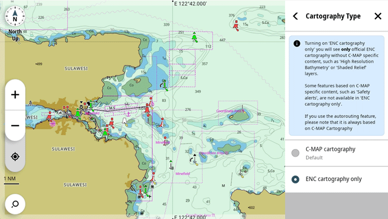
The new ENC (Electronic Navigational Charts) Cartography option allows you to see a representation of the official chart created by the national hydrographic offices around the world*.
*Please be aware that chart cannot be used in an IMO approved ECDIS System and is not available in all locations.
![]()
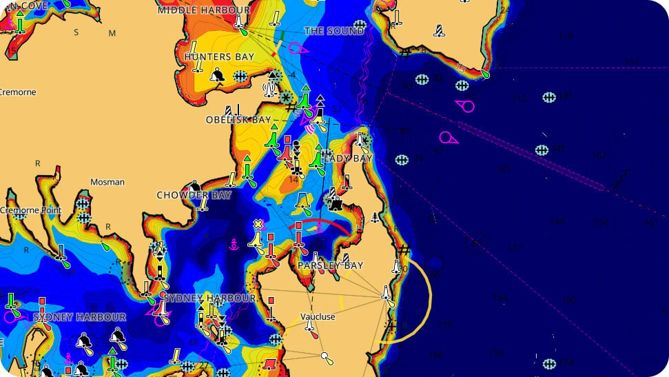
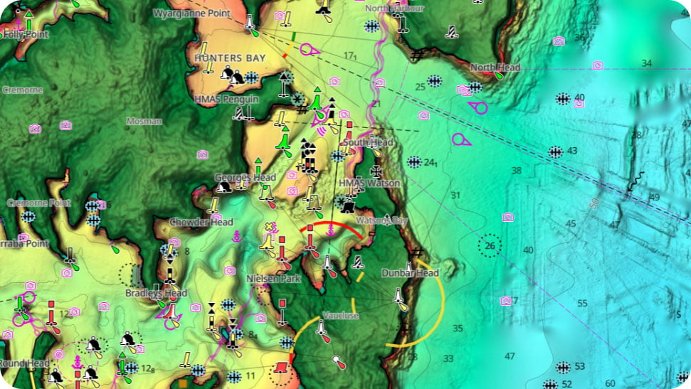
Hi-Res Bathymetry Layer
Identify shallow areas, drop offs, ledges, holes or humps. Includes the very best of C-MAP® HRB data, with integrated Genesis® social map data.
![]()
Custom Depth Shading
Allows you to set a safety depth or create your own shading and level-up your fishing – see things your way.
![]()
Tides & Currents
Show projections of water level and directions of tides to help plan your day out, whether cruising or fishing.
![]()
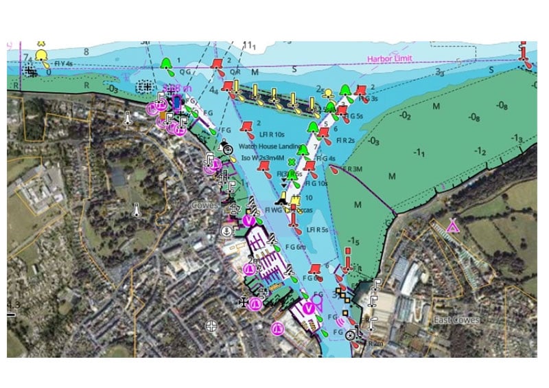
Marina & Port Plans
Docking in an unfamiliar port is no problem when you have precise layouts of thousands of marinas, including slip spaces, restricted areas and other valuable navigation information.
![]()
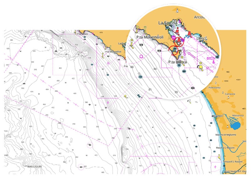
Harbor & Approach Details
Unprecedented level of detail. Approach any harbor and inlet with confidence. The perfect partner at the end of a long cruise or an exciting day of fishing.
![]()
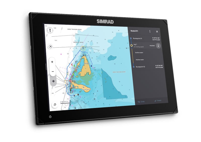
Subscription-Free Autorouting
Automatically plot the shortest, safest route based on detailed chart data and your personalized vessel information.
Keep your chart current, with 12 months free online updates for all DISCOVER™ X and REVEAL™ X charts.
![]()
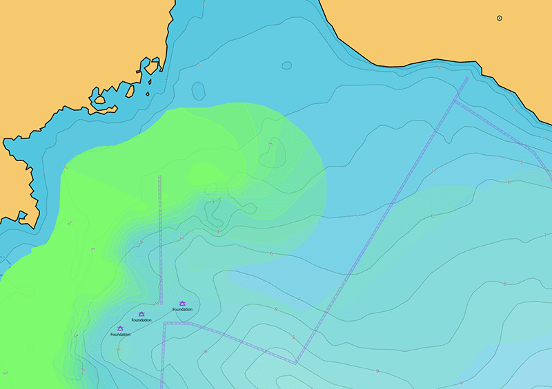
Upgrade your day on the water. Experience the next level of navigation with REVEAL™ X. Includes all the rich data and features in DISCOVER™ X, plus additional layers to enrich your time on the water. Increase your situational awareness with Satellite Overlay and level-up your fishing with game-changing REVEAL™ Shaded Relief layer.
Bring the world around you to life, with 3D rendered land and underwater elevation – including areas of Ultra-High-Res Bathymetric imagery – a game-changer for anglers and divers.
Satellite imagery gives information about the surroundings when you find yourself in an unfamiliar place. Stay safer on the water by maximizing your situational awareness.
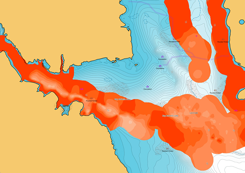
Big fish ambush little fish in submerged vegetation. Turn on the Vegetation layer to show the location, shape and depth of grass flats, deep weedlines, isolated patches and more**.
Fish love hard bottoms. They feed on them, breed on them, follow their edges like roads. The new bottom hardness layer shows the location, shape and depth of hard-bottom areas**.
**Vegetation and Bottom Hardness layer not available in all locations.
COMPARISON
| DISCOVER™ X | |
| Next Generation Charts | |
| Smooth App Integration | |
| Intuitive Map Inspector Tool | |
| Full-Featured Vector Charts | |
| Hi-Res Bathymetry | |
| Custom Depth Shading | |
| Best-In-Class Day & Night Modes | |
| Tides & Currents | |
| Detailed Marina Port Plans | |
| Harbor & Approach Details | |
| Subscription-Free Autorouting | |
| 12 Months Free, Easy Updates | |
| Connected Experience – Future-Proof | |
| ENC Cartography Option | |
|
REVEAL™ X |
|
| Next Generation Charts | |
| Smooth App Integration | |
| Intuitive Map Inspector Tool | |
| Full-Featured Vector Charts | |
| Hi-Res Bathymetry | |
| Custom Depth Shading | |
| Best-in-class Day & Night Modes | |
| Tides & Currents | |
| Detailed Marina Port Plans | |
| Harbor & Approach Details | |
| Subscription-Free Autorouting | |
| 12 Months Free, Easy Updates | |
| Connected Experience – Future-Proof | |
| ENC Cartography Option | |
| Shaded Relief REVEAL Layer | |
| Satellite Imagery | |
| Vegetation Layer | |
| Border Hardness Layer | |
COMPARISON
| DISCOVER™ X | |
| Next Generation Charts | |
| Smooth App Integration | |
| New Map Inspector Tool | |
| Full-Featured Vector Charts | |
| Hi-Res Bathymetry | |
| Custom Depth Shading | |
| Best-In-Class Day & Night Modes | |
| Tides & Currents | |
| Detailed Marina Port Plans | |
| Harbor & Approach Details | |
| Subscription-Free Autorouting | |
| 12 Months Free, Easy Updates | |
| Connected Experience – Future-Proof | |
| ENC Cartoraphy Option | |
|
REVEAL™ X |
|
| Next Generation Charts | |
| Smooth App Integration | |
| Intuitive Map Inspector Tool | |
| Full-Featured Vector Charts | |
| Hi-Res Bathymetry | |
| Custom Depth Shading | |
| Best-in-class Day & Night Modes | |
| Tides & Currents | |
| Detailed Marina Port Plans | |
| Harbor & Approach Details | |
| Subscription-Free Autorouting | |
| 12 Months Free, Easy Updates | |
| Connected Experience – Future-Proof | |
| ENC Cartography Option | |
| Shaded Relief REVEAL Layer | |
| Satellite Imagery | |
| Vegetation Layer | |
| Bottom Hardness Layer | |
*C-MAP App requires separate download from Apple App Store or Google Play store. 12 months premium access is included with any purchase of a C-MAP Discover X or Reveal X chart (bundled with a compatible MFD, SD card or Digital download). Once the 12 months is up, an additional purchase is required for continuous use. App availability and the terms of service may vary by country and region. You must register the chart, and 12-month access is from registration of the chart or the first time the chart is inserted into a compatible MFD.
Navico Group reserves the right to modify or discontinue this promotion at any time, without prior notice. Such changes may include, but are not limited to, altering the terms of the offer or terminating the PREMIUM mobile app subscription. In the event of any changes or termination, Navico Group will make reasonable efforts to inform customers through appropriate channels, including but not limited to, email notifications, website updates, or in-app notifications.


