The Best of C-MAP in an App
Superior Charts. Premium Planning
Superior Charts. Premium Planning
 The Best of C-MAP in an App
Superior Charts. Premium Planning
Superior Charts. Premium Planning
Download FREE now


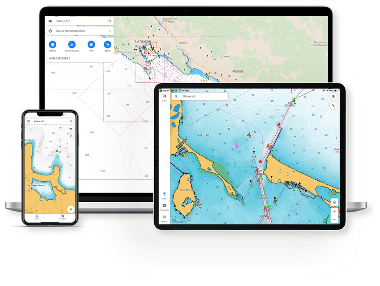
Planning and Navigation Made Simple
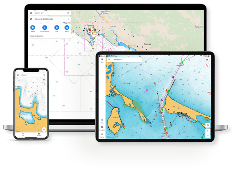
With the C-MAP App always have the latest most detailed chart data to hand, on your phone, tablet or PC; personalise your experience with the chart layers that you need – view your charts, your way. Planning routes has never been easier, save your favourite destinations or fishing spots in the App, check the weather, and when it’s time to go, create your route or let Autorouting do it for you.
Get premium access to the C-MAP® app for 12 months with any purchase of C-MAP DISCOVER™ X or REVEAL™ X charts. Gain access to exclusive features like your GPS Position, 5-day Weather Along the Route, Anchoring Alert and more. Experience new layers including Shaded Relief and Satellite Imagery.

Chart Features


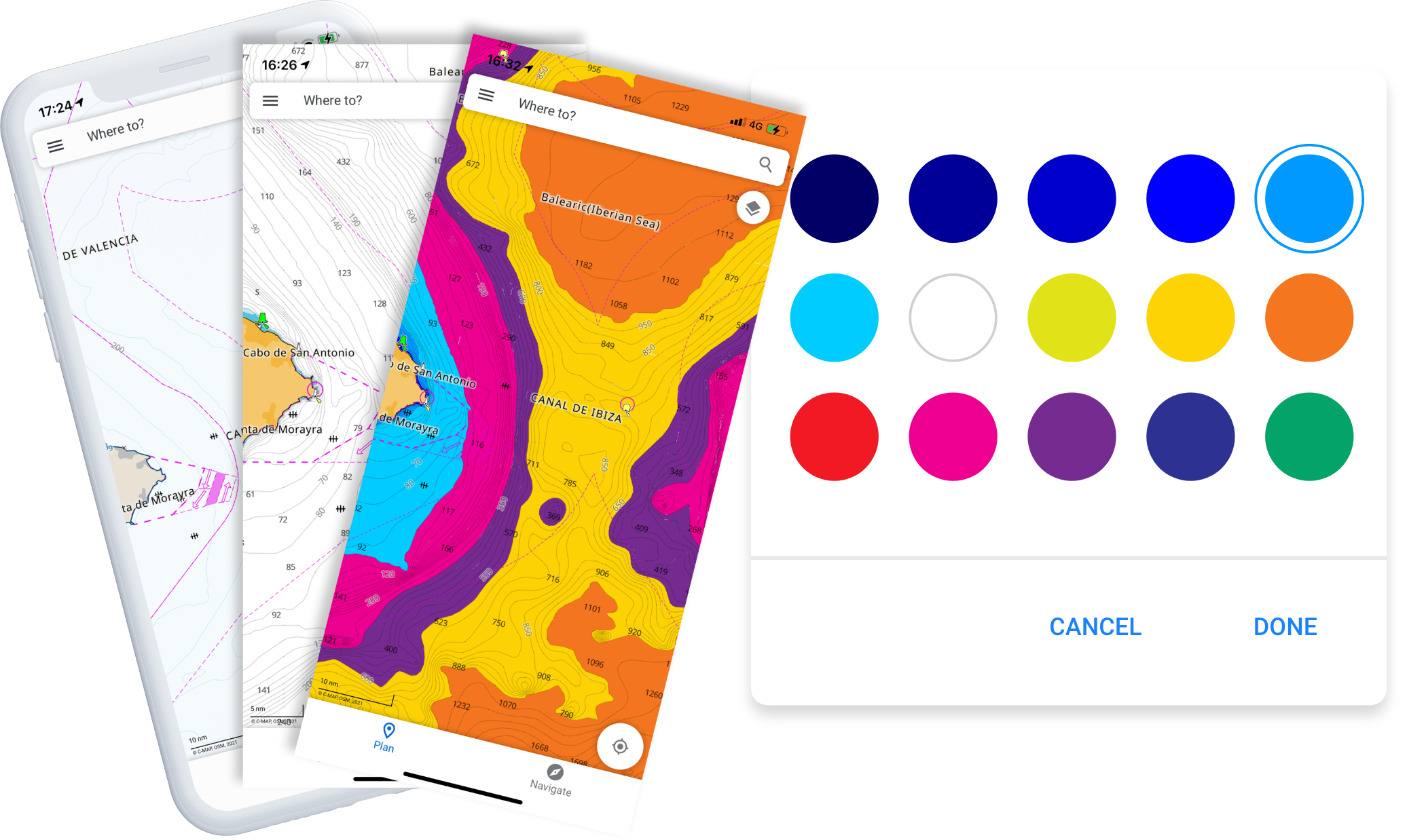
Your Charts, Your Way
C-MAP charts maintain accuracy while staying free from clutter. Customise your charts for the perfect fit. Turn on the features you love, select your unit of measurement, change the map type to suit and make use of the extensive Points of Interest pre-loaded or add your own.
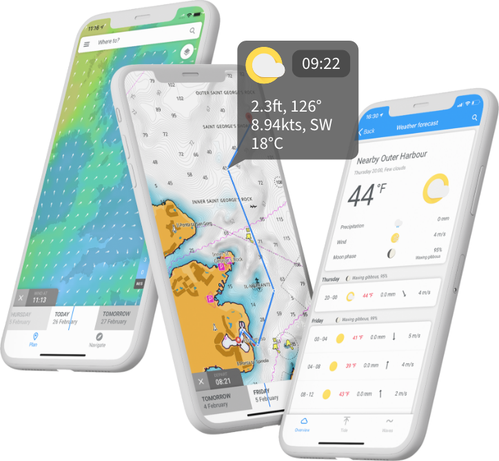
Weather
Plan your trips and stay safe on the water with our high accuracy weather features. You can check the weather forecast, with air and water temperature, wind and wave data, precipitation, tides, moon phase and more. You can also plan with Autorouting and check the weather along this route for the next 5 days. You can even view weather data overlaid on the chart.
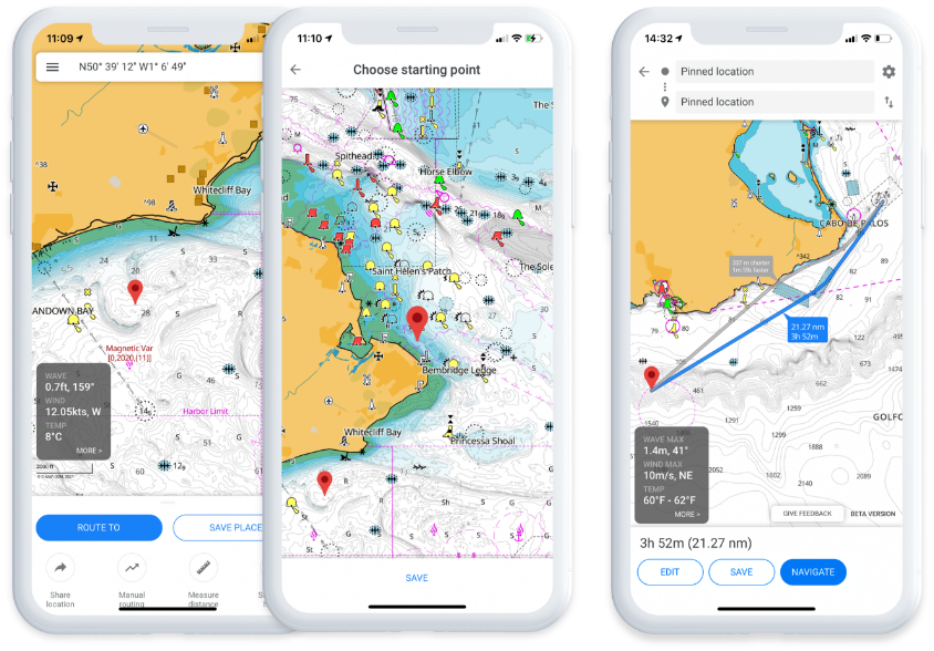
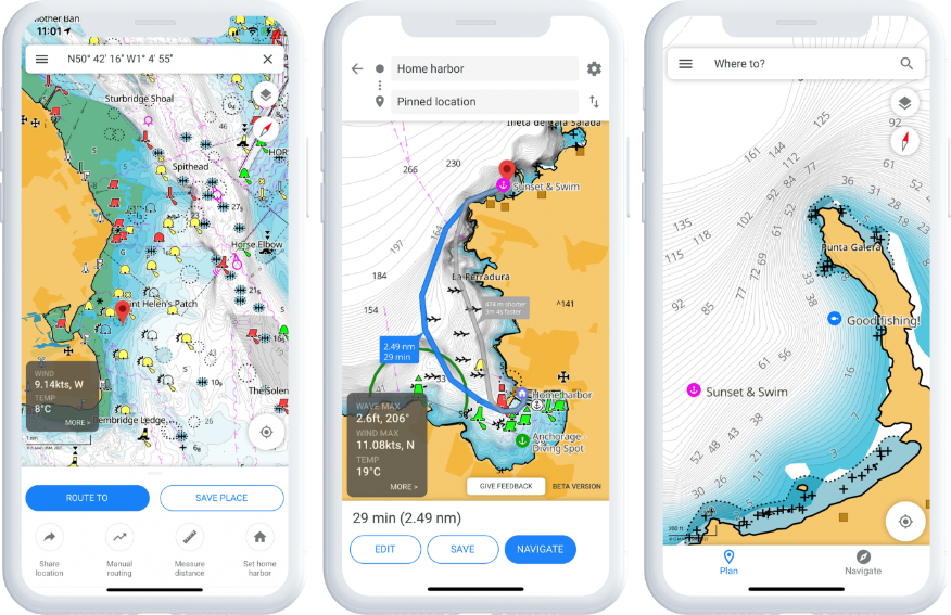
Routes, Tracks & Waypoints
Make the most of your time on the water by planning your Routes in advance – you’ll be ready to go in no time! Tracks show a “breadcrumb trail” so you can repeat a route or share with friends. Save your favourite places with personal Waypoints; choose the icon, edit the coordinates, even add a photo and some notes.
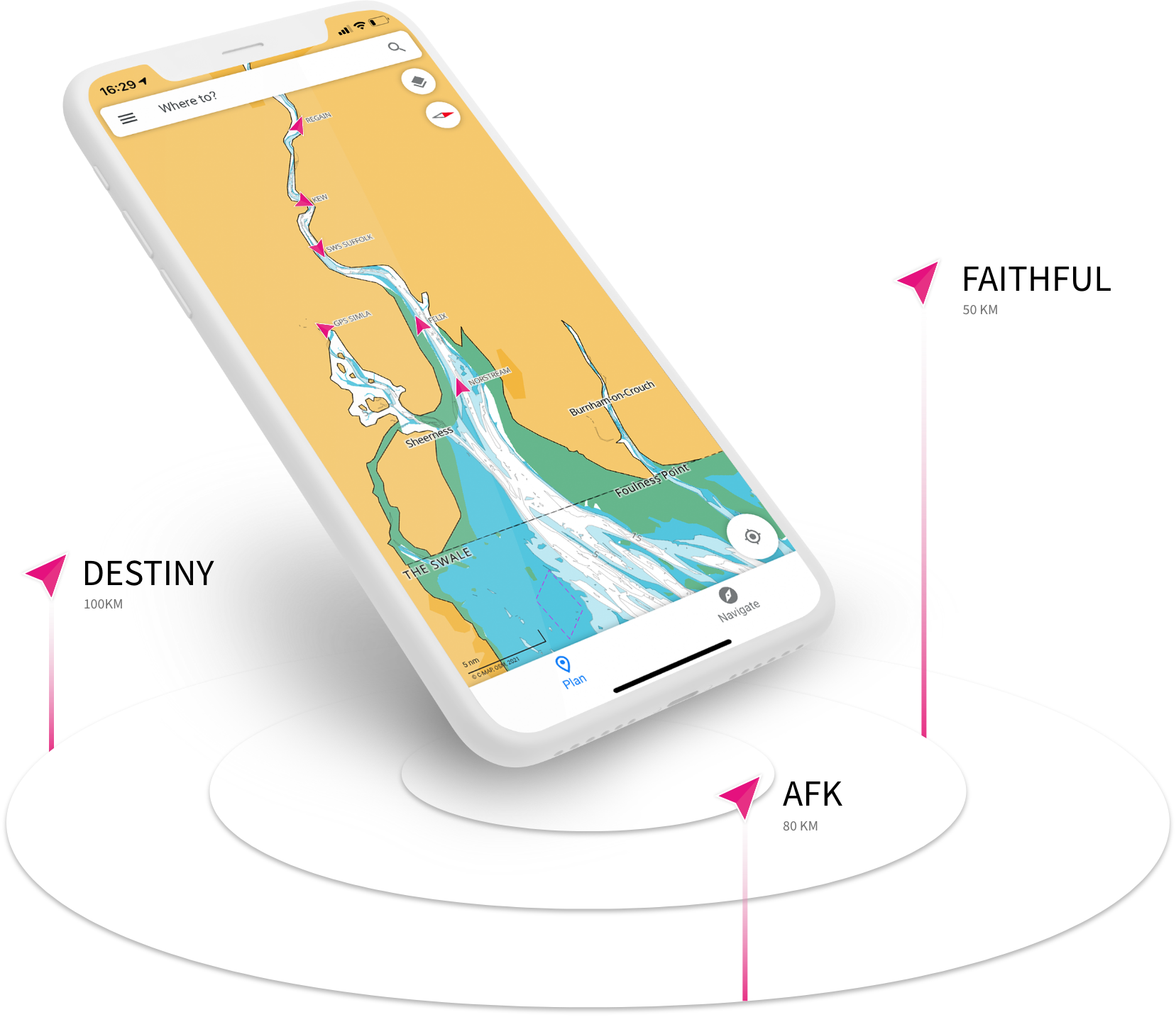
C-MAP Traffic & AIS
Stay safe on the water by increasing your situational awareness. See all boats with Class A and B enabled AIS within a 100km radius of your current position. View their position, speed and course. In high-traffic areas or in low visibility, AIS can help to keep you informed and safe on the water. With C-MAP Traffic you can keep track of friends and see the locations of fellow App-users.
![]()
Autorouting
Simply select a location or one of your saved Places to get a suggested route and ETA. You can even plan in advance from your computer and sync to your Tablet or Mobile.
![]()
Points of Interest
Explore marinas, harbors, beaches and more. Includes information such as VHF channels, number of berths in a marina, draft and length, amenities, and even photos and reviews from other users.
![]()
High Resolution Bathymetry
Helps you identify shallows, drop-offs, ledges, holes or humps through contour lines accurate down to a 1-ft level of detail.
![]()
Custom Depth Shading
Set a clear safety depth to make navigation safer, to create a paper chart-like view or set your own custom view and see things your way.
![]()
GPX Import & Export
Easily import GPX files into your App – perfect if you have Routes, Tracks or Waypoints saved outside of the App, or if a friend wants to share a route. You can also export the same way.
![]()
Anchoring Alert
Use your GPS position through your Mobile or Tablet to set an Anchoring Alert. Be notified if your anchor starts to drag away from your set anchoring point. * coming soon
Some features only available to Premium Subscribers
Subscription Comparison
| FREE | |
| View The Latest Nautical Charts | |
| Manual And Autorouting | |
| Add Personal Routes & Record Tracks | |
| Add Personal Waypoints | |
| GPX Import & Export | |
| Thousands Of Points Of Interest | |
| Marine Weather Forecast | |
| Weather Along the Route (24 Hours) | |
| Chart Personalisation | |
| Measure Distance Tool | |
| NEW: Sharing Tracks | |
| NEW: Personalised Push Notifications | |
|
PREMIUM EVERYTHING IN FREE, PLUS: |
|
| GPS Position & Full Navigation | |
| Unlimited Offline Maps (Global) | |
| 5-Day Weather Along the Route | |
| 5-Day Weather Overlay | |
| High Resolution Bathymetry | |
| Custom Depth Shading | |
| AIS | |
| C-MAP Traffic: View other App users | |
| Shaded Relief | |
| NEW: Anchoring Alert | |
| NEW: Satellite Overlay | |
Subscription Comparison
| FREE | |
| View The Latest Nautical Charts | |
| Manual And Autorouting | |
| Add Personal Routes & Record Tracks | |
| Add Personal Waypoints | |
| GPX Import & Export | |
| Thousands Of Points Of Interest | |
| Marine Weather Forecast | |
| Weather Along the Route (24 Hours) | |
| Chart Personalisation | |
| Measure Distance Tool | |
| NEW: Sharing Tracks | |
| NEW: Personalised Push Notifications | |
|
PREMIUM EVERYTHING IN FREE, PLUS: |
|
| GPS Position & Full Navigation | |
| Unlimited Offline Maps (Global) | |
| 5-Day Weather Along the Route | |
| 5-Day Weather Overlay | |
| High Resolution Bathymetry | |
| Custom Depth Shading | |
| AIS | |
| C-MAP Traffic: View other App users | |
| NEW: Anchoring Alert | |
| NEW: Satellite Overlay | |
Welcome to the C-MAP® App
How to use Autorouting
How to use Weather Along the Route
Compatibility

Ratings and Reviews


Reviews from Google Play store. Edited for brevity. Rating correct at 15.05.2021
Download FREE now
*C-MAP App requires separate download from Apple App Store or Google Play store. 12 months premium access is included with any purchase of a C-MAP Discover X or Reveal X chart (bundled with a compatible MFD, SD card or Digital download). Once the 12 months is up, an additional purchase is required for continuous use. App availability and the terms of service may vary by country and region. You must register the chart, and 12-month access is from registration of the chart or the first time the chart is inserted into a compatible MFD.
Navico Group reserves the right to modify or discontinue this promotion at any time, without prior notice. Such changes may include, but are not limited to, altering the terms of the offer or terminating the PREMIUM mobile app subscription. In the event of any changes or termination, Navico Group will make reasonable efforts to inform customers through appropriate channels, including but not limited to, email notifications, website updates, or in-app notifications.


